Photogrammetry Environment 3d Models & Textures
Photo scanning or Photogrammetry is a process that calculates the three-dimensional points of a surface using photo’s of a single physical real world object taken from different angles.
You take a large number of pictures of the object (generally at least 50-60 are needed, but for very high res objects hundreds of images may be needed) from all possible directions, then use these photos as an input for software that generates a 3d model. The software will look for features that are visible in multiple pictures and try to calculate from which point the picture was taken.
Knowing the camera positions and orientations, it creates a 3D point cloud that corresponds to the 2D details on the photo, think of a point cloud as millions of dots in 3d world space (X,Y,Z Possitions).
This point cloud can then be used to generate polygons connecting these dots together to create a surface skin that represents the object. Not only does it create the model but uses the photo’s to texture the 3d model creating a final photoreal version of that real world object in the computer.
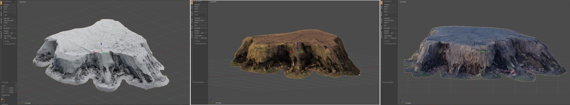


The images shown above are just a few examples of the 3D models generated by us to be included in our terrain environment packs, The finished packs will include High Res models and lower poly count bakes ready for realtime environment usage.
Project included
Photography, Blender 3D, Meshroom Photogrametry software,
3D Model creations, including:
- Roads
- Bollards
- Telephone poles
- Ground clutter
- Tree stumps
- Speed bumps
- Mud banks
- Rocks
- Cliffs
All objects have been retopologised to include lower polygon versions and texture baked ready for realtime game environments engines like UE4, Unity etc.
